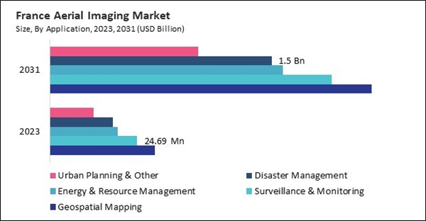
The Germany market dominated the Europe Aerial Imaging Market by country in 2023, and is expected to continue to be a dominant market till 2031; thereby, achieving a market value of $533.6 million by 2031. The UK market is exhibiting a CAGR of 14.7% during 2024-2031. Additionally, the France market is expected to experience a CAGR of 16.4% during 2024-2031.
The expanding utility of these imaging is particularly evident in urban planning and infrastructure development. Modern cities face complex challenges that require innovative solutions to manage rapid population growth, evolving transportation needs, and the continuous demand for sustainable development. These imaging provides urban planners with unprecedented details crucial for mapping existing infrastructure, planning new developments, and optimizing traffic flow.
These imaging has become a crucial tool for environmental monitoring and resource management, enabling governments and organizations to track deforestation, assess water resources, and evaluate agricultural health with unparalleled accuracy. Advanced imaging sensors mounted on drones, aircraft, and satellites capture subtle changes in vegetation health and soil moisture that traditional ground-based methods often miss.
The European market benefits from strict environmental policies, increasing smart city projects, and advancements in renewable energy infrastructure. Governments across Germany, the UK, and France are leveraging these imaging for urban planning, land management, and climate change monitoring. Additionally, the defense sector in Europe has shown a growing interest in surveillance and border security applications, further driving the adoption of these imaging solutions. The increasing demand for UAV-based infrastructure inspection in sectors like construction, transportation, and energy also contributes to market growth. These imaging has experienced a substantial increase in the media and entertainment sector in Italy, a country renowned for its tourism-driven economy and rich cultural heritage. Film production houses, tourism boards, and event organizers have increasingly adopted drone-based aerial videography to enhance content creation and promotional campaigns. Thus, as industries continue to embrace AI-powered analytics, 3D mapping, and cloud-based aerial imaging solutions, Europe remains at the forefront of technological advancements and market expansion in this market.
List of Key Companies Profiled
- Google LLC (Alphabet Inc.)
- Esri, Inc.
- Hexagon AB
- Trimble, Inc.
- DroneDeploy, Inc.
- Nearmap Ltd.
- EagleView Technology Corporation
- Kucera International Inc.
- Cooper Aerial Surveys Co.
- High Eye Aerial Imaging Inc.
Market Report Segmentation
By Platform
- UAV
- Fixed-Wing Aircraft
- Helicopter
- Other Platform
By Application
- Geospatial Mapping
- Surveillance & Monitoring
- Energy & Resource Management
- Disaster Management
- Urban Planning & Other
By End Use
- Government
- Agriculture & Forestry
- Military & Defense
- Energy
- Civil Engineering
- Commercial
- Media & Entertainment
- Other End Use
By Country
- Germany
- UK
- France
- Russia
- Spain
- Italy
- Rest of Europe
Table of Contents
Companies Mentioned
- Google LLC (Alphabet Inc.)
- Esri, Inc.
- Hexagon AB
- Trimble, Inc.
- DroneDeploy, Inc.
- Nearmap Ltd.
- EagleView Technology Corporation
- Kucera International Inc.
- Cooper Aerial Surveys Co.
- High Eye Aerial Imaging Inc.


