Global Terrestrial Laser Scanning Market - Key Trends and Drivers Summarized
How Is Terrestrial Laser Scanning Enhancing Geospatial Data Collection?
Terrestrial laser scanning (TLS) is a surveying technology that uses laser beams to capture highly accurate 3D data of physical environments. This technology is used in applications like topographic surveys, construction planning, mining, archaeology, and forestry, providing detailed geospatial data for analysis and decision-making. TLS offers advantages such as rapid data acquisition, high resolution, and precision, making it ideal for complex projects that require detailed 3D modeling. As industries increasingly adopt geospatial technologies, terrestrial laser scanning has become essential for mapping, measurement, and visualization tasks.What Are the Key Segments in the Terrestrial Laser Scanning Market?
Key types include mobile, static, and aerial TLS, with static TLS holding the largest market share due to its widespread use in construction, architecture, and infrastructure mapping. Applications cover surveying, 3D modeling, construction planning, heritage documentation, and environmental monitoring, with surveying representing a significant segment driven by demand for accurate topographic data. End-users include construction firms, mining companies, government agencies, and environmental researchers, with construction firms dominating the segment as TLS supports efficient site mapping, planning, and monitoring.How Is Terrestrial Laser Scanning Integrated Across Industries?
In the construction sector, TLS is used to capture detailed 3D models of buildings, bridges, and infrastructure, supporting planning, design, and progress monitoring. In mining, TLS provides high-resolution mapping of mines, supporting safety analysis, resource estimation, and operational planning. In archaeology, TLS is used for documenting historical sites, providing detailed 3D models for conservation and study. Additionally, in forestry, TLS helps measure tree height, volume, and biomass, supporting forest management, research, and conservation efforts.What Factors Are Driving the Growth in the Terrestrial Laser Scanning Market?
The growth in the Terrestrial Laser Scanning market is driven by several factors, including increasing demand for precise geospatial data, rising adoption of 3D modeling in construction, and advancements in laser scanning technology. Innovations like mobile scanners, improved data processing algorithms, and AI integration have supported broader applications in mapping and analysis. The focus on improving project accuracy, reducing surveying time, and supporting sustainable planning has further fueled demand, as TLS provides critical insights for various industries. Additionally, expanding infrastructure projects, growing emphasis on heritage conservation, and the need for accurate environmental monitoring have contributed to market growth, encouraging the use of terrestrial laser scanning across sectors.Report Scope
The report analyzes the Terrestrial Laser Scanning market, presented in terms of market value (US$ Thousand). The analysis covers the key segments and geographic regions outlined below.- Segments: Type (Phase-Shift, Pulse-based, Mobile); Application (Building Information Modeling, Surveying, Research & Engineering, Other Applications).
- Geographic Regions/Countries:World; United States; Canada; Japan; China; Europe (France; Germany; Italy; United Kingdom; Spain; Russia; and Rest of Europe); Asia-Pacific (Australia; India; South Korea; and Rest of Asia-Pacific); Latin America (Argentina; Brazil; Mexico; and Rest of Latin America); Middle East (Iran; Israel; Saudi Arabia; United Arab Emirates; and Rest of Middle East); and Africa.
Why You Should Buy This Report:
- Detailed Market Analysis: Access a thorough analysis of the Global Terrestrial Laser Scanning Market, covering all major geographic regions and market segments.
- Competitive Insights: Get an overview of the competitive landscape, including the market presence of major players across different geographies.
- Future Trends and Drivers: Understand the key trends and drivers shaping the future of the Global Terrestrial Laser Scanning Market.
- Actionable Insights: Benefit from actionable insights that can help you identify new revenue opportunities and make strategic business decisions.
Key Questions Answered:
- How is the Global Terrestrial Laser Scanning Market expected to evolve by 2030?
- What are the main drivers and restraints affecting the market?
- Which market segments will grow the most over the forecast period?
- How will market shares for different regions and segments change by 2030?
- Who are the leading players in the market, and what are their prospects?
Report Features:
- Comprehensive Market Data: Independent analysis of annual sales and market forecasts in US$ Million from 2024 to 2030.
- In-Depth Regional Analysis: Detailed insights into key markets, including the U.S., China, Japan, Canada, Europe, Asia-Pacific, Latin America, Middle East, and Africa.
- Company Profiles: Coverage of players such as 3D Digital Corporation, Ametek, Inc, Basic Software Inc., Blom ASA, Carl Zeiss Optotechnik and more.
- Complimentary Updates: Receive free report updates for one year to keep you informed of the latest market developments.
Some of the 33 companies featured in this Terrestrial Laser Scanning market report include:
- 3D Digital Corporation
- Ametek, Inc
- Basic Software Inc.
- Blom ASA
- Carl Zeiss Optotechnik
- Creaform (Ametek)
- Faro Technologies
- Fugro N.V.
- General Electric
- Harvey-Lynch, Inc
- Hexagon Geosystems
- Leica Geosystems HDS, LLC
- Maptek
- Merrett Survey
- RIEGL Laser Measurement Systems GmbH
- Teledyne Technologies
- Trimble
- Zoller + Fröhlich
This edition integrates the latest global trade and economic shifts into comprehensive market analysis. Key updates include:
- Tariff and Trade Impact: Insights into global tariff negotiations across 180+ countries, with analysis of supply chain turbulence, sourcing disruptions, and geographic realignment. Special focus on 2025 as a pivotal year for trade tensions, including updated perspectives on the Trump-era tariffs.
- Adjusted Forecasts and Analytics: Revised global and regional market forecasts through 2030, incorporating tariff effects, economic uncertainty, and structural changes in globalization. Includes historical analysis from 2015 to 2023.
- Strategic Market Dynamics: Evaluation of revised market prospects, regional outlooks, and key economic indicators such as population and urbanization trends.
- Innovation & Technology Trends: Latest developments in product and process innovation, emerging technologies, and key industry drivers shaping the competitive landscape.
- Competitive Intelligence: Updated global market share estimates for 2025, competitive positioning of major players (Strong/Active/Niche/Trivial), and refined focus on leading global brands and core players.
- Expert Insight & Commentary: Strategic analysis from economists, trade experts, and domain specialists to contextualize market shifts and identify emerging opportunities.
Table of Contents
Companies Mentioned (Partial List)
A selection of companies mentioned in this report includes, but is not limited to:
- 3D Digital Corporation
- Ametek, Inc
- Basic Software Inc.
- Blom ASA
- Carl Zeiss Optotechnik
- Creaform (Ametek)
- Faro Technologies
- Fugro N.V.
- General Electric
- Harvey-Lynch, Inc
- Hexagon Geosystems
- Leica Geosystems HDS, LLC
- Maptek
- Merrett Survey
- RIEGL Laser Measurement Systems GmbH
- Teledyne Technologies
- Trimble
- Zoller + Fröhlich
Table Information
| Report Attribute | Details |
|---|---|
| No. of Pages | 273 |
| Published | January 2026 |
| Forecast Period | 2024 - 2030 |
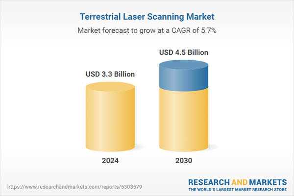
| Estimated Market Value ( USD | $ 3.3 Billion |
| Forecasted Market Value ( USD | $ 4.5 Billion |
| Compound Annual Growth Rate | 5.7% |
| Regions Covered | Global |


