A Complete Database of Earth Observation Value Added Service Market Players
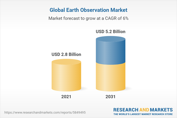
The global earth observation market was valued at USD 2.8 billion in 2021, and is projected to reach USD 5.2 billion by 2031, witnessing a CAGR of 6% over the forecast period.
Earth observation technologies have revolutionized industries worldwide, offering a wealth of geospatial data and insights for various applications, from agriculture and environmental monitoring to urban planning and disaster management. This report offers comprehensive profiles of a wide range of market players, unveiling their unique contributions, specialties, and strategic approaches, shaping the burgeoning market of Earth Observation Value Added Services.
Key Highlights
- Key data of companies' size and niche;
- Companies' clients and KPI;
- Financial data: revenue and funding.
Reasons to Buy
- Market assessment and competitor research;
- Find out potential cooperation or clients;
- Determine an investment opportunity in the Earth Observation Value Added Service Market.
All data is in an Excel file.
At least 20 companies mentioned in this research:
- Airbus is a European multinational aerospace corporation;
- Maxar Technologies is an American space technology company;
- Orbital Insight is an American geospatial analytics company that analyzes satellite and aerial imagery;
- Iceye is a Finnish microsatellite manufacturer that provides SAR satellite imagery;
- Capella Space is an American space company that provides SAR satellite imagery;
- Rezatec is a UK-based geospatial analytics company;
- Satellogic is a company that develops Earth-observation satellites and provides satellite imagery analytics;
- BlackSky is an American operator of the own satellite constellation that provides satellite imagery analytics;
- SATIM Monitoring Satelitarny is a Poland company that delivers SAR satellite imagery analytics;
- KSAT is a Norwegian-based company, operator of the ground station network, also provides satellite imagery analytic;
- Preligens is a French startup that delivers satellite imagery analytics;
- Ursa Space Systems is an American satellite intelligence company;
- Photosat is a Canadian company that specializes in satellite imagery analytics for the Mining and Geology;
- Descartes Labs is an American satellite intelligence company;
- Ecometrica is a UK-based company that specializes in the measuring GHG emissions;
- Satelligence is a Dutch company that specializes in the solutions for the Forestry niche;
- Tre Altamira is an Italian company that specializes in the SAR analytics;
- 3V Geomatics is a Canadian company that specializes in the SAR analytics;
- Kayrros is a company that provides satellite imagery analytics, including carbon monitoring;
- Interpine Innovation is a New Zeeland company specializing in the Earth-observation data analytics for the Forestry niche;
- Hatfield Consultants is a Canadian company that provides satellite imagery analytics.
The full list of companies you can find in the database.
The comprehensive database of Earth observation value-added service market players is a valuable resource for various stakeholders within the Earth observation industry and related sectors such as:
- Earth Observation Companies: Companies providing Earth observation value-added services can use this report to identify competitors, potential partners, and market trends to enhance their business strategies.
- Investors and Venture Capital Firms: Investors seeking opportunities in the Earth observation market can benefit from the report to assess the competitive landscape and potential investment targets.
- Market Researchers and Analysts: Professionals conducting market research or analysis in the Earth observation sector can use the database as a reliable source of information to study market dynamics and perform competitive analysis.
- Government Agencies and Policymakers: Government entities involved in Earth observation policy and regulation can utilize the report to understand the market players, their capabilities, and contributions to the industry.
- Academic Institutions and Researchers: Researchers in the field of Earth observation, remote sensing, or related disciplines can access the database to study the market ecosystem, emerging trends, and identify gaps for further exploration.
The report can serve as a valuable resource for informed decision-making, market analysis, and strategic planning in the Earth observation value-added service sector.
Executive Summary
The Ecosystem of Earth Observation Value Added Service Market Players report presents an extensive analysis of the diverse and dynamic landscape of companies providing Earth Observation Value Added Services.
The primary objective of this report is to provide a holistic understanding of the Ecosystem of Earth Observation Value Added Service Market Players. By presenting detailed profiles of numerous companies, the report aims to offer valuable insights into their products, capabilities, geographic reach, and industry focus. This comprehensive analysis equips stakeholders, investors, researchers, and policymakers with a well-rounded view of the Earth observation market, facilitating informed decision-making and fostering collaboration within the industry.
The report delves into comprehensive profiles of a diverse array of Earth Observation Value Added Service providers. Each company's background, mission, range of services, technological capabilities, and notable achievements are meticulously documented. These profiles highlight the unique value propositions and competitive advantages that define each market player's presence within the Earth observation ecosystem.
The profiles include information structured into the following sections:
- General Information: company website, legal entities, year of foundation or product release, type (private or public), HQ location, number of employees, whether they own any satellites, country coverage.
- Business model characteristics: reselling of satellite images, provision of satellite imagery analytics, platforms, analytic tool, business model.
- Features matrix: API, alerts / reports, AOI polygon highlights, change detection, type of satellite imagery (optic or SAR), drone / aerial photography, lidar, AIS, base map, integrations.
- Financial indicators and contracts: revenue, profit, total investments raised, last round date and amount, lead investors, active investors, government contracts, known clients.
- Verticals: Urban monitoring (Infrastructure / civil), Agriculture, Forestry, Mining & Oil & Gas, Water / Maritime, Location Based Services, Energy (utility), Disaster management, Environment, Defence, Finance / Insurance, Transport and logistics, Education & academic, Mapping & GIS.
- Matrix of satellites used as sources.
Scope
Having examined the list of 300 companies, the publisher has analyzed and defined: top players and verticals, commonly used satellites and their operators, as well as general characteristics of the Earth Observation Value Added Service market.
Companies Mentioned: Airbus, Maxar Technologies, Orbital Insight, Iceye, Capella Space, Rezatec, Bird.i, Satellogic, BlackSky, SATIM Monitoring Satelitarny, KSAT, Preligens, Catalyst, Collecte Localisation Satellites, Satellio, 3V Geomatics, Kazakhstan Gharysh Sapary, Spaceknow, Descartes Labs, Certeza Infosys, Ecometrica, Remote Sensing Metrics, SUR Emprendimientos Tecnológicos, Pachama, Satelligence, LiveEO, CollectiveCrunch, Interpine Group, Earth-i, Xacmaz Technology, OpenForests, Effigis, Karten Space, Allsource Analysis, Overstory, SpaceSense, Hatfield Consultants, Ursa Space Systems, OneSoil, Orbital Sidekick, Aratos Group, TerraMapping, SuperVision Earth, Novaterra Soluções em Geoinformção, GEO Data Design, Kayrros, Tre Altamira, Terrabotics, Ursa Space Systems, SkyGEO, 3V Geomatics, Photosat, Vortexa.
Countries: Argentina, Australia, Austria, Belarus, Belgium, Brazil, Cambodia, Canada, Chile, China, Colombia, Czech Republic, Denmark, Ecuador, Egypt, Finland, France, Gana, Germany, Ghana, Greece, Hungary, India, Indonesia, Israel, Italy, Japan, Kazakhstan, Kenya, Korea, Lebanon, Luxembourg, Mexico, Myanmar, Netherland, Netherlands, New Zealand, Norway, Peru, Philippines, Phillipine, Poland, Portugal, Russia, Serbia, Singapore, Slovenia, South Africa, South Korea, Spain, Sweden, Switzerland, Uganda, UK, Ukraine, USA.
Regions: North America, South America, Europe, Asia, Africa, Australia & Oceania.
Sourcing and Referencing: Data and analysis throughout the report is sourced using attached links.
Companies Mentioned
- 3V Geomatics
- Airbus
- Allsource Analysis
- Aratos Group
- Bird.i
- BlackSky
- Capella Space
- Catalyst
- Certeza Infosys
- Collecte Localisation Satellites
- CollectiveCrunch
- Descartes Labs
- Earth-i
- Ecometrica
- Effigis
- GEO Data Design
- Hatfield Consultants
- Iceye
- Interpine Group
- Interpine Innovation
- Karten Space
- Kayrros
- Kazakhstan Gharysh Sapary
- KSAT
- LiveEO
- Maxar Technologies
- Novaterra Soluções em Geoinformção
- OneSoil
- OpenForests
- Orbital Insight
- Orbital Sidekick
- Overstory
- Pachama
- Photosat
- Preligens
- Remote Sensing Metrics
- Rezatec
- Satelligence
- Satellio
- Satellogic
- SATIM Monitoring Satelitarny
- SkyGEO
- Spaceknow
- SpaceSense
- SuperVision Earth
- SUR Emprendimientos Tecnológicos
- Terrabotics
- TerraMapping
- Tre Altamira
- Ursa Space Systems
- Vortexa
- Xacmaz Technology
Table Information
| Report Attribute | Details |
|---|---|
| Published | November 2023 |
| Forecast Period | 2021 - 2031 |
| Estimated Market Value ( USD | $ 2.8 Billion |
| Forecasted Market Value ( USD | $ 5.2 Billion |
| Compound Annual Growth Rate | 6.0% |
| Regions Covered | Global |
| No. of Companies Mentioned | 52 |


