Free Webex Call
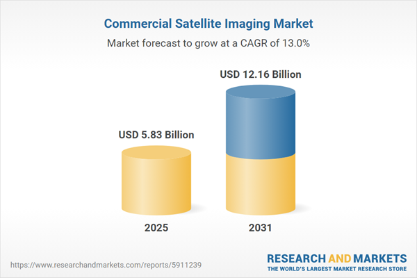
The projected market size for the global commercial satellite imaging market is expected to reach USD 8.06 billion by the end of 2022, with a compound annual growth rate (CAGR) of 12.46% during the forecast period. The global commercial satellite imaging market has undergone a significant evolution, driven by advancements in satellite technology and the growing demand for accurate geospatial information across diverse industries. Commercial satellite imaging involves the capture and analysis of high-resolution images and data from Earth's surface using orbiting satellites. These images serve a myriad of purposes, including environmental monitoring, urban planning, disaster management, defense intelligence, agriculture, and infrastructure development. The market has been revolutionized by the emergence of private satellite operators deploying small satellite constellations, enabling more frequent and affordable image acquisition. Additionally, the integration of advanced imaging sensors and data analytics techniques has enhanced the quality and utility of satellite imagery, allowing for precise geospatial analysis. Industries are increasingly reliant on this technology for informed decision-making, resource management, and strategic planning.Speak directly to the analyst to clarify any post sales queries you may have.
10% Free customizationThis report comes with 10% free customization, enabling you to add data that meets your specific business needs.
Key Market Drivers
The Growing Demand for Location-Based Service (LBS)The global commercial satellite imaging market is experiencing a significant surge in growth driven by the escalating demand for Location-Based Services (LBS). In today's digital landscape, businesses and consumers alike are increasingly relying on LBS to provide personalized and context-aware experiences. From navigation and geotagging to real-time asset tracking and targeted advertising, LBS leverage precise location information to deliver relevant content and services. This surge in LBS adoption has led to a corresponding increase in the need for accurate and up-to-date geospatial data, which is where commercial satellite imaging comes into play. Satellites equipped with advanced imaging sensors capture high-resolution imagery of Earth's surface, enabling the creation of detailed maps and real-time data feeds for various LBS applications.
Industries such as logistics, transportation, retail, and urban planning benefit immensely from LBS-powered solutions. Delivery services optimize routes for quicker shipments, retailers send location-specific promotions to customers' smartphones, and cities use geospatial data for efficient urban development. Commercial satellite imaging provides the foundation for these services by offering the necessary geographic context. The demand for LBS is projected to continue growing as businesses seek to provide more personalized and convenient experiences to their customers. This trend, in turn, fuels the demand for accurate and reliable satellite imagery, positioning the global commercial satellite imaging market at the forefront of technological advancements that cater to the evolving needs of the location-based services ecosystem.
The emergence of Small Satellite Constellations Operated by Private Companies
The global commercial satellite imaging market is experiencing a transformative growth trajectory, primarily propelled by the emergence of small satellite constellations operated by private companies. This disruptive trend has revolutionized the space industry, making satellite imagery more accessible, frequent, and versatile. Private companies are launching constellations of small satellites that work collaboratively to capture comprehensive and up-to-date imagery of Earth's surface. These constellations enable rapid revisit rates, which translates to near-real-time monitoring and data acquisition, a capability previously reserved for larger, government-operated satellites.The adoption of small satellite constellations has expanded the application scope of satellite imaging across various industries. Sectors such as agriculture, environmental monitoring, disaster management, and urban planning benefit from the rapid and frequent data updates that these constellations provide. Furthermore, private companies have leveraged advancements in miniaturization and cost-effective manufacturing to deploy constellations at lower expenses, democratizing access to satellite imagery for businesses, researchers, and governments. This trend not only increases market competitiveness but also stimulates innovation and fosters entrepreneurship within the space industry. It has led to a paradigm shift, where the market is no longer dominated solely by governmental agencies but also by dynamic private entities seeking to address diverse commercial demands. As small satellite constellations continue to evolve and amass global coverage capabilities, the commercial satellite imaging market's growth trajectory remains intrinsically linked to the proliferation of these innovative constellations, reshaping how Earth observation data is collected, disseminated, and utilized across a myriad of sectors.
Advancements in Satellite Technology
The global commercial satellite imaging market is experiencing substantial growth driven by continuous advancements in satellite technology. Innovations in satellite design, miniaturization, imaging sensors, and communication systems have collectively revolutionized the capabilities and accessibility of satellite imagery. High-resolution imaging sensors capture intricate details of Earth's surface, while miniaturized satellites enable the deployment of cost-effective small satellite constellations. These constellations enhance revisit rates, enabling frequent and real-time data updates for various applications. Additionally, improved communication systems facilitate the rapid transmission of imagery, ensuring seamless delivery to end-users.These technological breakthroughs have expanded the market's reach, enabling not only established players but also startups to offer cutting-edge satellite imaging services. The decreasing cost of manufacturing and launching satellites has lowered barriers to entry, fostering innovation and competition. As satellites become more advanced, versatile, and capable of capturing data across various spectral ranges, the commercial satellite imaging market is poised to cater to an array of industries, from agriculture and environmental monitoring to defense and disaster management. The relentless pursuit of satellite technology innovation is a driving force behind the market's growth, promising further enhancements in imaging quality, revisit rates, and overall operational efficiency.
The Growing Demand for Geospatial Data
The global commercial satellite imaging market is experiencing robust growth due to the escalating demand for accurate and up-to-date geospatial data. Businesses, governments, and industries are increasingly recognizing the value of geospatial data in making informed decisions, optimizing operations, and gaining competitive advantages. Satellite imaging plays a pivotal role in meeting this demand by providing high-resolution imagery that offers insights into Earth's surface and changes over time. From urban planning and infrastructure development to natural resource management and disaster response, the applications of geospatial data are diverse and far-reaching. As the global economy becomes more interconnected and data-driven, the need for real-time, location-based insights intensifies. The commercial satellite imaging market is well-positioned to address this demand by delivering timely and accurate geospatial information that empowers stakeholders across various sectors to navigate complex challenges and seize emerging opportunities.Key Market Challenges
Concern Related to Data Security and Privacy
The growth of the global commercial satellite imaging market is being hindered by concerns related to data security and privacy. As satellite imagery becomes increasingly accessible and the volume of collected data expands, the potential for misuse and unauthorized access raises significant apprehensions. Geospatial data often contains sensitive information about locations, infrastructure, and activities that, if compromised, could have serious consequences. Governments, businesses, and individuals alike are wary of the potential misuse of this data for surveillance, espionage, or cyberattacks. Striking a balance between providing valuable insights while safeguarding privacy rights becomes a critical challenge. To foster sustainable growth in the commercial satellite imaging market, robust data protection mechanisms, encryption techniques, and stringent access controls are essential. Addressing these concerns through transparent data handling practices and adherence to regulatory frameworks will be crucial to maintaining trust and ensuring that the benefits of satellite imaging technology can be fully realized without compromising individual privacy or national security.The Increasing Availability of High-Resolution Imagery Raises Ethical
The global commercial satellite imaging market faces a challenge due to the ethical concerns arising from the increasing availability of high-resolution imagery. While advanced imaging technology enables the capture of incredibly detailed and accurate images of Earth's surface, it also raises ethical questions about privacy invasion and surveillance. The ability to zoom in on private properties, sensitive locations, and individual activities has sparked debates about the responsible and ethical use of such data. Striking a balance between leveraging high-resolution imagery for legitimate purposes like urban planning, disaster response, and environmental monitoring, while respecting individual and societal rights, is a complex endeavor. Regulators, industry players, and advocacy groups are actively working to establish guidelines and regulations that ensure the responsible and ethical application of this technology. Addressing these concerns in a transparent and responsible manner will be crucial for the sustained growth of the commercial satellite imaging market, allowing it to harness its potential while upholding the values of privacy and ethical use of data.Key Market Trends
The Integration with AI and Data Analytics
The growth of the global commercial satellite imaging market is significantly driven by the integration of Artificial Intelligence (AI) and advanced data analytics. The convergence of satellite imagery with AI-powered algorithms and data analysis techniques has unlocked new dimensions of value from geospatial data. AI-driven image recognition and pattern detection algorithms enable efficient automated processing of vast amounts of satellite imagery, extracting valuable insights and identifying trends that would be challenging for manual analysis. This integration enhances the speed and accuracy of interpreting satellite imagery, making it a valuable tool for applications such as agriculture, urban planning, environmental monitoring, and disaster response. Data analytics platforms further complement this integration by transforming raw imagery into actionable intelligence, enabling informed decision-making for businesses, governments, and organizations worldwide. As AI and data analytics capabilities continue to evolve, the commercial satellite imaging market is poised to further expand its capabilities, offering enhanced solutions that leverage the synergy between cutting-edge technology and geospatial data.The Emergence of IoT and Connected Technologies
The global commercial satellite imaging market is experiencing substantial growth due to the emergence of the Internet of Things (IoT) and connected technologies. As IoT devices and sensors become increasingly prevalent, they generate massive amounts of data that require efficient monitoring and analysis. Commercial satellite imaging is uniquely positioned to provide a comprehensive view of Earth's surface, capturing changes, patterns, and events in real time. The integration of satellite imagery with IoT data allows businesses, governments, and industries to gain deeper insights into various processes, from agricultural monitoring and infrastructure management to environmental assessment and disaster response. This synergy enables timely decision-making and proactive actions based on a holistic understanding of interconnected systems. As IoT adoption continues to expand across industries, the commercial satellite imaging market is poised to play a pivotal role in harnessing the power of connected technologies, driving innovation, and enabling data-driven strategies on a global scale.Segmental Insights
Application Insights
Based on application, the geospatial data acquisition & mapping based emerges as the predominant segment, exhibiting unwavering dominance projected throughout the forecast period. This segment encompasses a wide range of industries and sectors that rely on accurate and up-to-date geospatial information for diverse purposes, such as urban planning, infrastructure development, environmental monitoring, and disaster response. The ability to capture detailed imagery of Earth's surface from space offers valuable insights that drive decision-making and innovation across various domains. As urbanization, resource management, and environmental conservation become increasingly vital, the demand for geospatial data acquisition and mapping continues to surge.End User Insights
Based on end user, the military & defense segment emerges as a formidable frontrunner, exerting its dominance and shaping the market's trajectory throughout the forecast period. The military and defense sector leverages satellite imaging technology for a range of critical applications, including surveillance, intelligence gathering, reconnaissance, and mission planning. The high-resolution imagery provided by commercial satellites enhances situational awareness, aids in identifying potential threats, and assists in strategic decision-making. As geopolitical tensions and security concerns continue to drive investments in defense capabilities, the demand for accurate and real-time satellite imagery remains steadfast.Regional Insights
North America emerges as the dominating region within the global Commercial Satellite Imaging market, propelled by a confluence of strategic factors that collectively highlight its pivotal influence on shaping the industry's growth trajectory. With a rich history of space exploration and technological innovation, North America boasts an advanced ecosystem that encompasses satellite manufacturing, imaging technologies, and robust infrastructure. Moreover, the region's defense, intelligence, and commercial sectors drive substantial demand for satellite imagery for purposes ranging from national security to urban planning and agriculture. The presence of major satellite imaging companies, research institutions, and government agencies contributes to North America's leadership in this domain. As the demand for high-resolution and real-time satellite data escalates across various sectors, North America's established expertise positions it at the forefront of technological advancements, cementing its commanding influence in the global Commercial Satellite Imaging market.Report Scope:
In this report, the global commercial satellite imaging market has been segmented into the following categories, in addition to the industry trends which have also been detailed below:Global Commercial Satellite Imaging Market, By Technology:
- Optical
- Radar
Global Commercial Satellite Imaging Market, By Application:
- Geospatial Data Acquisition & Mapping
- Natural Resource Management
- Surveillance & Security
- Conservation & Research
- Construction & Development
- Disaster Management
- Defense & Intelligence
Global Commercial Satellite Imaging Market, By End User:
- Government
- Construction
- Transportation & Logistics
- Military & Defense
- Energy
- Forestry & Agriculture
- Other
Global Commercial Satellite Imaging Market, By Region:
- North America
- Europe
- South America
- Middle East & Africa
- Asia Pacific
Competitive Landscape
Company Profiles: Detailed analysis of the major companies present in the Global Commercial Satellite Imaging Market.Available Customizations:
Global Commercial Satellite Imaging market report with the given market data, the publisher offers customizations according to a company's specific needs.This product will be delivered within 1-3 business days.
Table of Contents
1. Service Overview
2. Research Methodology
7. Global Commercial Satellite Imaging Market Outlook
8. North America Commercial Satellite Imaging Market Outlook
9. Europe Commercial Satellite Imaging Market Outlook
10. South America Commercial Satellite Imaging Market Outlook
11. Middle East & Africa Commercial Satellite Imaging Market Outlook
12. Asia Pacific Commercial Satellite Imaging Market Outlook
13. Market Dynamics
15. Company Profiles
Companies Mentioned
- BlackSky Global LLC
- European Space Imaging (EUSI) GmbH
- DigitalGlobe Inc.
- L3Harris Corporation Inc.
- UrtheCast Corporation Inc.
- Galileo Group Inc.
- ImageSat International NV
- Planet Labs Inc.
- SpaceKnow Inc.
- Skylab Analytics Inc.