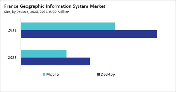
The Germany market dominated the Europe Geographic Information System Market by country in 2023, and is expected to continue to be a dominant market till 2031; thereby, achieving a market value of $1.56 billion by 2031. The UK market is exhibiting a CAGR of 7.6% during 2024-2031. Additionally, the France market is expected to experience a CAGR of 9.3% during 2024-2031.
GIS has revolutionized the agricultural industry by enabling precision farming. It allows farmers to monitor real-time soil conditions, weather patterns, and crop health. With spatial data, farmers can apply fertilizers, pesticides, and water resources more efficiently, maximizing crop yield while minimizing environmental impact. GIS is critical for environmental management and conservation efforts.
GIS applications in transportation help optimize routes, manage traffic systems, and plan public transportation infrastructure. In logistics, companies use GIS to track the movement of goods, optimize delivery routes, and reduce fuel consumption. GIS also plays a key role in the planning and operation of airports, railways, and ports. GIS is used in real estate for site selection, market analysis, and investment decisions.
The mining and quarrying sector in Europe, particularly in countries like Poland and Germany, plays a vital role in the economy and drives the demand for geographic information system (GIS) solutions. As the mining industry generates significant value-added output, GIS technology is increasingly becoming essential for enhancing operations in these industries. Integrating GIS into mining operations is helping to optimize exploration, resource management, environmental monitoring, and safety, leading to substantial growth in the market across Europe. In 2020, the mining and quarrying sector in the European Union generated €27.1 billion in value-added, with a notable contribution from non-metallic mining and quarrying, accounting for 40.5% of the EU sector’s turnover. GIS solutions are indispensable for companies in these sectors as they support the detailed mapping of mineral deposits, land reclamation, and efficient resource extraction. Hence, as the European mining industry grows, the need for advanced GIS solutions will continue to rise.
List of Key Companies Profiled
- Bentley Systems, Inc.
- Autodesk, Inc.
- Pitney Bowes, Inc.
- Hexagon AB
- Schneider Electric SE
- Pasco Corporation
- Ubisense Ltd.
- SuperMap Software Co.,ltd.
- Environmental Systems Research Institute
- MacDonald, Dettwiler and Associates Ltd.
Market Report Segmentation
By Devices
- Desktop
- Mobile
By Component
- Services
- Software
- Hardware
By Usage
- Navigation
- Mapping
- Surveying
By Vertical
- Utilities
- Transportation & Logistics
- Aerospace & Defense
- Construction
- Agriculture
- Mining & Geology
- Oil & Gas
- Government & Others
By Country
- Germany
- UK
- France
- Russia
- Spain
- Italy
- Rest of Europe
Table of Contents
Companies Mentioned
- Bentley Systems, Inc.
- Autodesk, Inc.
- Pitney Bowes, Inc.
- Hexagon AB
- Schneider Electric SE
- Pasco Corporation
- Ubisense Ltd.
- SuperMap Software Co.,ltd.
- Environmental Systems Research Institute
- MacDonald, Dettwiler and Associates Ltd.


